Nearly half of Michigan’s population lives in coastal areas and coastal employment amounts to $91.6 billion in annual wages, according to the National Oceanic and Atmospheric Administration. However, the coasts are changing and the “Great Lakes State” has experienced significant erosion along its nearly 3,288 linear miles of coastlines, stemming from unpredictable lake water levels and increased frequency and severity of storms. With approximately 387 coastal communities, this erosion is an important topic for state regulatory authorities, municipalities, and homeowners alike. In an effort to increase coastal resilience, a team from Michigan State University seeks to harnass local knowledge and involvement by teaching some community members how to use drones to collect critical information.
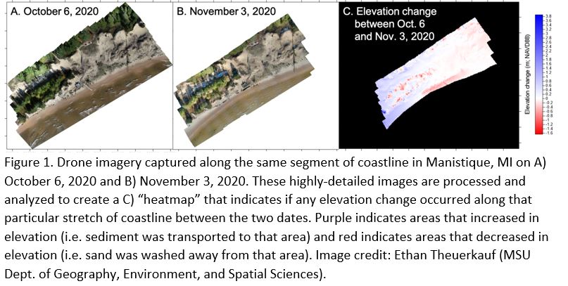
This project, developed by MSU’s Department of Geography, Environment, and Spatial Sciences and Remote Sensing and GIS Research and Outreach Services and funded by the National Science Foundation, seeks to engage select Michigan coastal communities by hosting workshops with key stakeholders, training citizen scientists to collect highly-detailed drone imagery of critical coastline segments.
Three more workshops planned
Two workshops, one each in Marquette and Manistique, were held in 2020 in the Upper Peninsula. Remaining workshops are planned for 2021 in Iosco County, South Haven, and Manistee. These communities were selected by researchers due to their unique combination of both socioeconomic factors and exhibiting signs of significant coastal erosion.
As part of these workshops, researchers hope to recruit an interested community member to serve as a citizen scientist drone pilot to collect images of the shoreline in their area before and after periods of significant erosion (i.e. storms, gale warnings, wave action). These community members will be trained by MSU specialists on how to responsibly operate drones and licensed by the Federal Aviation Administration before collecting any data. A typical workshop consists of:
- an overview of shoreline history in the community,
- an exercise that allows participants to pinpoint areas of coastal erosion on a map,
- an activity to highlight common coastal hazards and seek the existing knowledge of participants,
- focus groups to gather information on coastline change and related decision-making in each community, and
- a description of the use of citizen scientist drone pilots to gather high-resolution aerial photographs of the shoreline before and after storms.
Analyzing data
After citizen scientists collect images of the coastline via drone, researchers may analyze images before and after storms to tell if there has been any significant changes in the landscape due to erosion.
Researchers plan to make the imagery collected by citizen scientists publicly accessible and hope the data will promote active management and lasting resilience along Great Lakes coastlines. If you live or work in the communities of Iosco County, South Haven, or Manistee and would like to attend a workshop, please contact Dr. Erin Bunting at [email protected].
Michigan Sea Grant helps to foster economic growth and protect Michigan’s coastal, Great Lakes resources through education, research and outreach. A collaborative effort of the University of Michigan and Michigan State University and its MSU Extension, Michigan Sea Grant is part of the NOAA-National Sea Grant network of 34 university-based programs.
This article was prepared by Michigan Sea Grant under award NA180AR4170102 from the National Oceanic and Atmospheric Administration, U.S. Department of Commerce through the Regents of the University of Michigan. The statements, findings, conclusions, and recommendations are those of the author(s) and do not necessarily reflect the views of the National Oceanic and Atmospheric Administration, the Department of Commerce, or the Regents of the University of Michigan.


