Water quality sensors and buoys in the Great Lakes must be able to withstand rough waves and harsh weather conditions. With funding from Michigan Sea Grant, a binational research team is finding new safe havens for sensor arrays in northern Michigan, expanding capacity to collect year-round data about Great Lakes water quality.
The St. Marys River is the sole outlet of Lake Superior, making it an ecologically and economically important node in the Great Lakes region. The river winds past Upper Peninsula Tribal communities and marks the international boundary between Sault Ste. Marie, Michigan, and Sault Ste. Marie, Ontario, on its way to Lake Huron. Cargo freighters and tourists flock to the river’s Soo Locks facility, and recreational and subsistence fishers ply the waters of this ecologically diverse region. Many species of fish spawn among the wide rapids present in the river.
At the same time, the St Marys River is also a federally recognized Binational Area of Concern due to a legacy of human activities and industrialization that have degraded water quality and aquatic habitats. Additionally, climate change is driving new and unpredictable shifts in water levels, water quality, ice cover, and fish population dynamics in Lake Superior and Lake Huron. Collecting long-term, continuous observations of water quality in the St. Marys River is key to advancing restoration projects, fisheries management, and climate change research.
However, high winds, strong waves, and extreme ice cover in the river and adjacent lakes have historically presented a challenge for buoys and underwater sensors attempting to collect and analyze water samples. Even with a 44-year trend of decreasing Great Lakes ice cover, researchers are hard-pressed to collect data and observations during winter months
Researchers behind a project called the “River Environment and Sensor Observation Network” (REASON) are trying to change that, one sensor at a time. Algoma University Professor of Biology and Environmental Science Michael Twiss developed REASON to install water sensors in Great Lakes connecting channels, a known gap in water quality monitoring data. The sensors are tucked inside hydropower stations where they can collect data without being exposed to harsh weather conditions. Twiss operated REASON sensors in the Moses-Saunders hydropower dam that spans the St. Lawrence River between New York and Ontario from 2014-2020. Over the past two years, REASON sensors have been installed in a municipal drinking water treatment plant in the Mohawk community at Akwesasne on the Saint Lawrence River, in partnership with Clarkson University and the River Institute in Cornwall, Ontario, and funded by the Great Lakes Observing System.

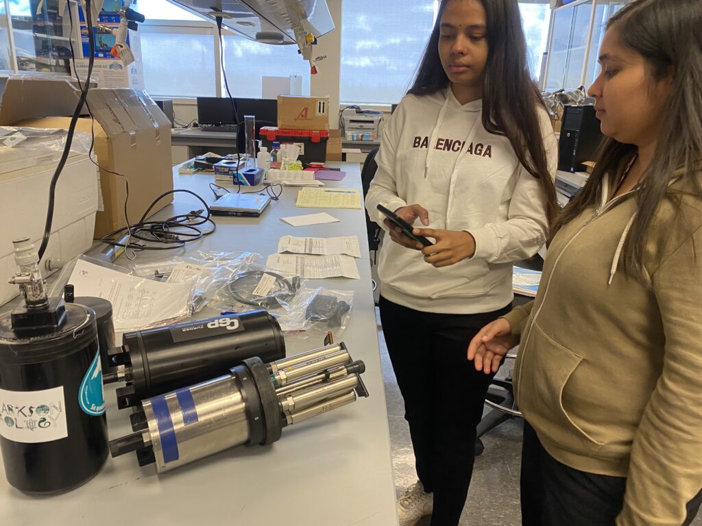
Two Algoma University students inspect sensors used in hydropower dam installations to measure water quality. The two student interns are Mansiben Gohil (center), and Aesha Soni (right). Photo: Michael Twiss
In early 2024, Michigan Sea Grant research funding enabled Twiss to team up with Ashley Moerke, director of the Center for Freshwater Research and Education at Lake Superior State University. The binational team has now expanded the REASON network by installing sensor arrays in one of three hydropower stations on the U.S. and Canadian sides of the St. Marys River. They plan to expand the installation to each of the three dams as well as to municipal water intakes downstream of Sault Ste Marie, as was done at Akwesasne.
The sensors will be strategically placed near the Soo Locks, where the river splits into multiple channels. A northern channel flows past the site of one of Canada’s largest steel mills before passing through the Brookfield hydropower station. A southern canal runs through downtown Sault Ste. Marie, Michigan, and rejoins the main river at the Cloverland Electric Cooperative hydropower plant. The central strand of the river weaves among lock structures and the Whitefish Island Indian Reserve on the way toward Sugar Island. Sensors are intended to be installed in all hydropower dams with the aim to capture any variations in water quality as the river flows from Lake Superior. The team anticipates having the sensors installed by Summer 2025.
The sensors provide real-time measurements for factors like temperature, turbidity, petroleum products, and chlorophyll (representing the amount of plankton in the water). Water samples will also be regularly collected for lab analysis to measure chloride, nitrate, and other nutrients.
The REASON project represents a unique binational partnership among academic units, government agencies, and private industry to help provide high-resolution water quality data to inform regulation, climate change strategies, land use development, and more. Data from the St. Marys River system can help enhance understanding of the seasonal and annual dynamics in the Upper Great Lakes and meet responsibilities toward maintaining healthy coastal ecosystems.


